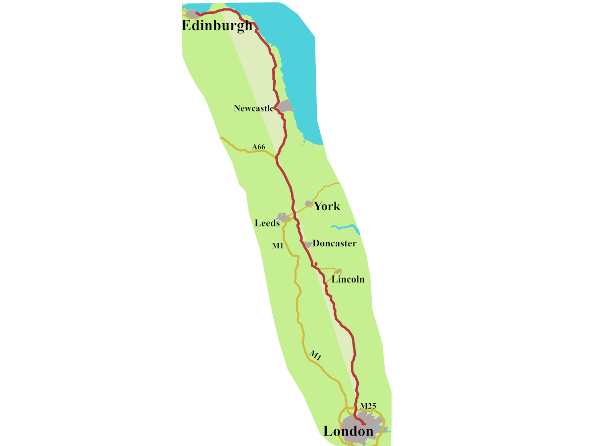
The A5 is one of many roads, too long, too old, and too loaded with history, to be contained in a single post. So, this post looks at the A5 through Wales, which has its own, particular history.
A Beginning
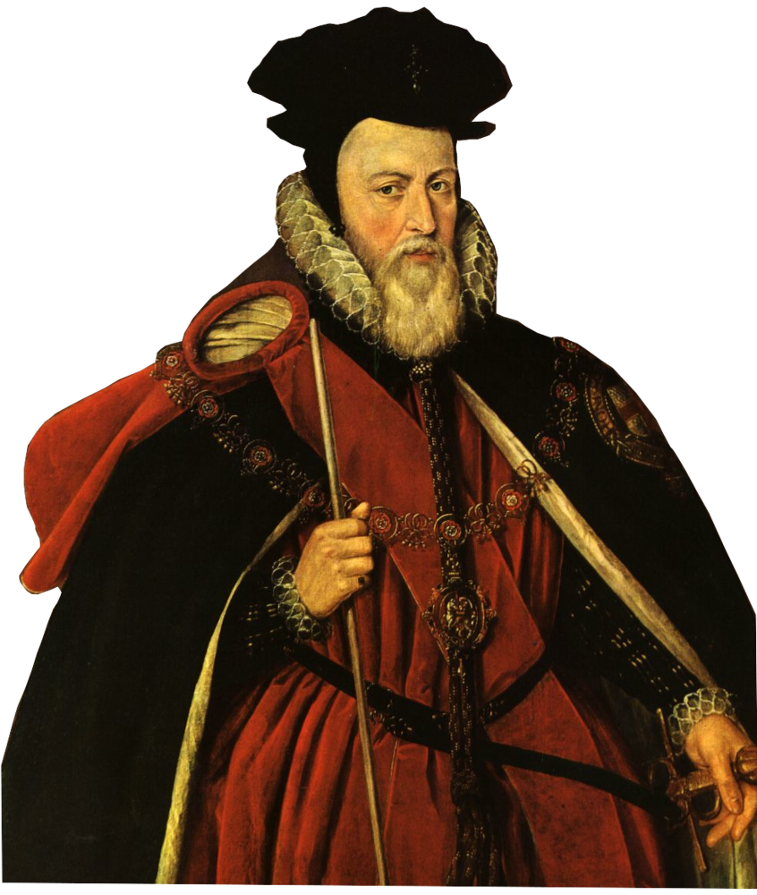
In 1561, Elizabeth I’s chief minister William Cecil gave orders “for the laying of the Posts”.
Holinshed tells us, it meant “there should be set Posts appointed between London and Ireland.”1
Better still, the mail went to Ireland from Holyhead, not by the A5, it’s true, but from Chester.
So, Holyhead? Yes.
The Holyhead Road? Not yet.
Of course people had lived along the route of the A5 from prehistoric times, and they would have used the river valleys, just as Thomas Telford did, and the road still does.
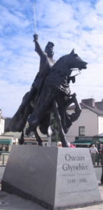
There were Iron Age hillforts at Dinas Bran near Llangollen, and Caer Drewyn, a mile north of Corwen, Caer Drewyn is associated with Owain Glyndŵr, whose dramatic statue stands in the square in Corwen.
Needless to say, the Romans caused trouble. In 60 CE, Guias Suctonius Paulinus led an expedition to root out resistance from the druids of Anglesey, (Mona to the Romans). He didn’t use the A5 route, but went from Chester, round the north coast, to Bangor, where they crossed the Menai Strait. He made short, and bloody work of the Britons, before having to hurry away to help with a bit of local difficulty in England: Boudica’s uprising.
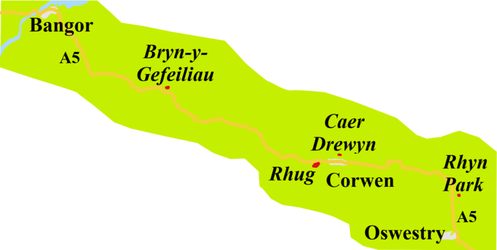
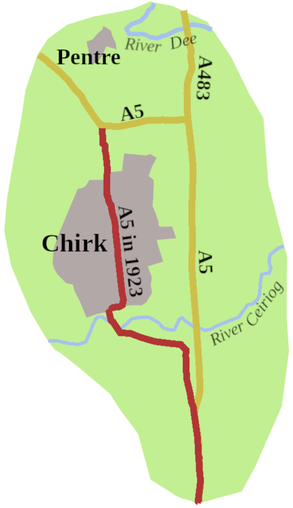
There was a Roman fort, perhaps two, at Rhyn Park, across the A5 from Chirk.2 From there, twenty miles of road, ran north of the Dee, to the Rhug Estate, near Corwen, which, today, boasts North Wales’s most exclusive farm shop.3
The road may have continued, because further west, near the A5, are earthworks believed to mark a short stretch of Roman road. Another fort stood, from around 90 CE, north of the A5, near Capel Curig.4 Perhaps the first stirrings of the A5?
Middle Years: No Real Road
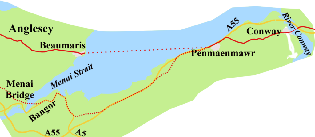
When Ogilby mapped the Road to Holyhead in the1670s, he followed the post route from Chester to Conway, where he marks a ferry over the river, in use until Thomas Telford’s Conway Suspension Bridge arrived in 1826.5 He does, however, give us an insight into the perilous nature of the Menai Strait crossing in the late seventeenth century.
It all depended on the state of the tide. When low, the postboy might follow a narrow, steep path over the seaward edge of Penmaenmawr mountain to reach what Ogilby calls “The Sands.”
“The Ascent being rough and steep, giving you a perpendicular Precipice or Declivity on the Right to the Sea, and a kind of over-hanging Rock of as great a height on the Left.”6
Intrepid voyagers then went across the mud to the water’s edge, where they hoped to attract the attention of the ferryman in Beaumaris. The boat was designed to take a horse, though it must have been a hazardous business rowing across the Strait with a horse on board.
If the tide were high, and you were not prepared to wait, you were forced to make the equally difficult trip along the Sychnant Pass. and over the top of Penmaenmawr Mountain.7 Having braved this peril, you continued to Bangor for a ferry to the town of Pothaethwy, which today is called, by the English at least, Menai Bridge.
Ogilby’s route across Anglesey is difficult to plot on a modern map, and has nothing to do with the A5. Eventually, he marks Llanenghhennel, the modern Llanynghenedl, now on the A5025, about eight miles from Holyhead. To reach Holy Island, the options were:
“observe the Right-hand Way to Cleveock Sands, leading to Holyhead when the Tide is out, otherwise you proceed by Way of the Bridg, unless 4 Furlongs farther you pass over the Sands and Rocks, all uniting before you come to Holyhead.”8
Going “by Way of the Bridg” refers to the road to Trearddur Bay, over Four Mile Bridge, which has been there since, at least, 1530.9 The bridge derives its name, not from its length, which would be amazing, but because it was reckoned to be four miles from Holyhead. The Road to Holyhead Ogilby described remained, more or less, the accepted route for the next hundred years.
Turnpikes to the Rescue?
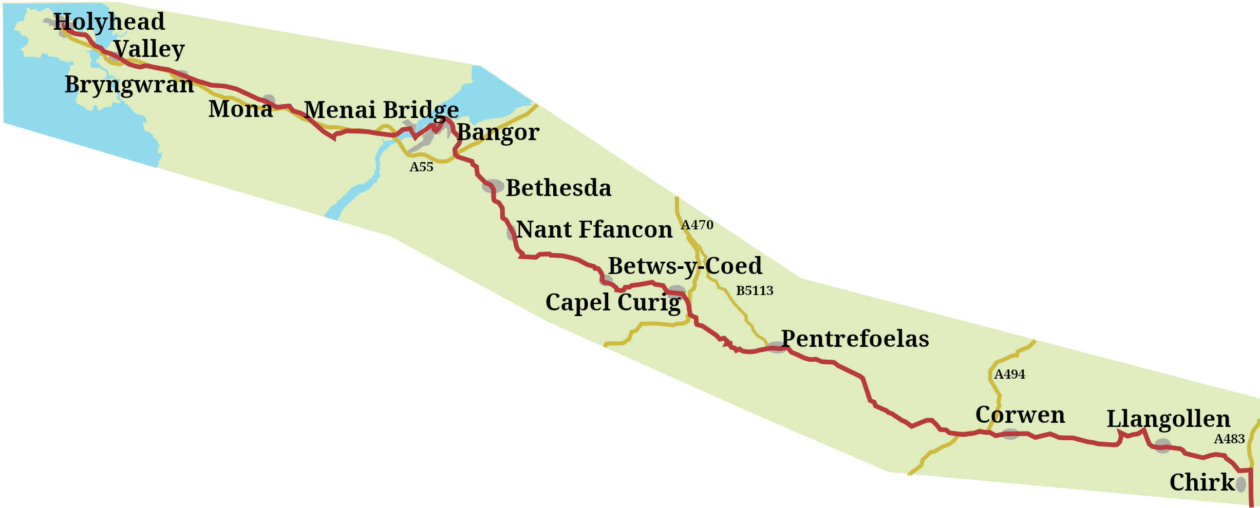
Eventually, about halfway through the eighteenth century, turnpike roads began to push along the road. You could ride, or drive, along a turnpike between Shrewsbury to Oswestry from 1752, and by 1777, have followed turnpikes through Llangollen, Corwen, and on another fifteen miles to Pentrefoelas.
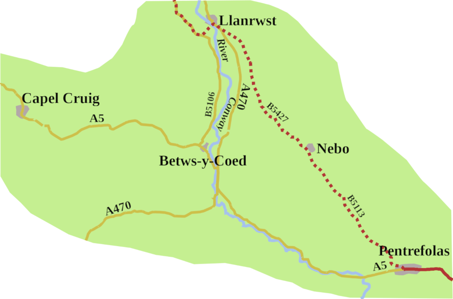
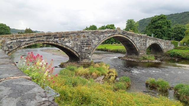
At Pentrefoelas, you abandoned the A5 to go through Nebo, to Llanrwst. Here you crossed the Conway over Pont Fawr, possibly designed by Inigo Jones. After that, you headed north to meet the Conway to Bangor turnpike.
This cross-country route was necessary, first because it avoided the ferry at Conway. Secondly, beyond Pentrefoelas the way was still little more than a track, with the section through the Nant Ffrancon Pass unuseble for much of the year
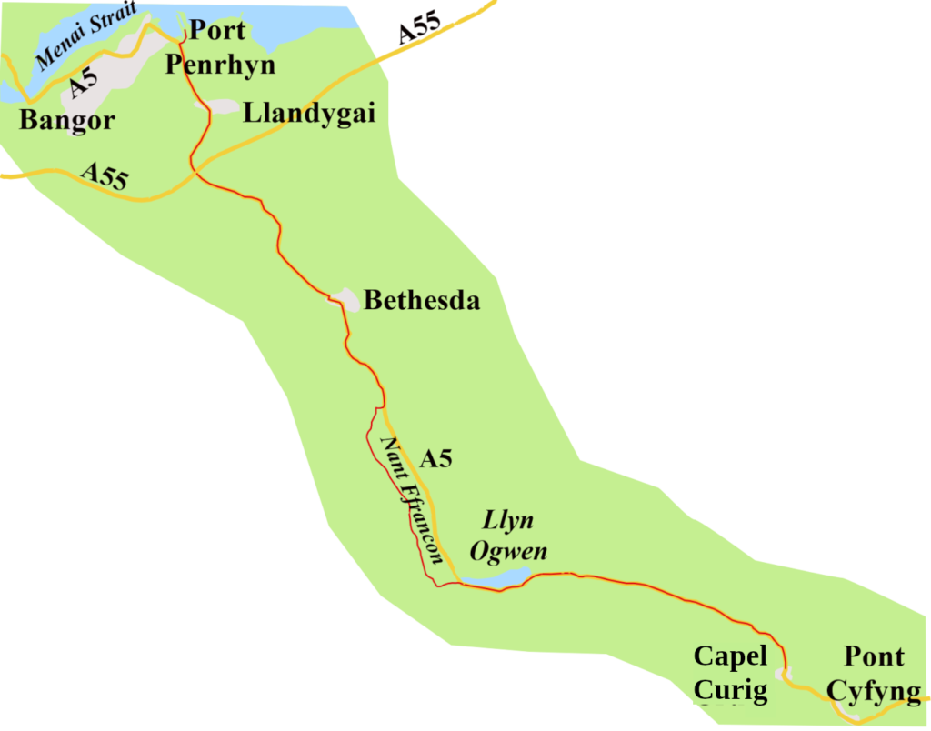
Then, in 1790, a quarry owner, Lord Penrhyn, began work on a road from Capel Curig, through Nant Ffrancon, as far as Llandygai so he could move slate to his harbour at Bangor. His lordship didn’t need to go to Pentrefoelas, so the road there from Capel Curig remained as bad as ever.
Twelve years on, the Capel Curig Turnpike Trust took responsibility for maintaining the whole stretch from Pentrefoelas to Llandygai. It didn’t follow the exact route of the A5, but crossed the Conway several times using pack-horse bridges. One such, Pont Rhydllanfair, with its telltale low parapets, can still be found by taking a left off the A5 by the Ty’r Bont B&B, (which I think is still there?) about three miles from Pentrefoelas, signed for Cwm Eidda. From Capel Curig, the turnpike could follow Lord Penrhyn’s road.
Once cross the Menai Strait, the first stop was the Three Tuns Inn. It’s still there, on Cambria Road, Menai Bridge, though now called the Cambria, and is no longer an inn.10 After that, you took the Porthaethwy Ferry to Holyhead turnpike, (1765 to 1823);11 not the A5 route, but cross-country to Llanynghenedl, and over Four Mile Bridge.
Thomas Telford’s Holyhead Road
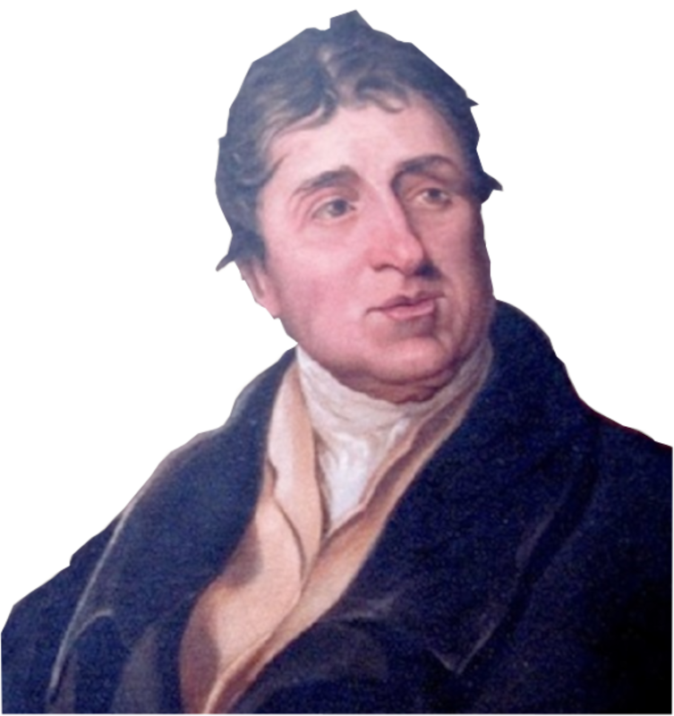
Following the Act of Union with Ireland in 1800, traffic along the road increased, as did the volume of complaints about the lamentable state of the road. In 1810, it was decided something must be done. That something was Thomas Telford’s survey of the road between Shrewsbury and Holyhead, published in 1811.
The government, as ever, was reluctant to lay out the cash, particularly with the war against Bonaparte at full pitch. So the Holyhead Road Commission was not established until 1815, but at least, Telford was made its engineer in chief. He straightway set about building a road that would be the A5 through Wales. The surface was smooth, slightly cambered, to allow water run off, and the gradient never more than 1 in 22.
Telford also built two bridges along the road that were critical to the whole project.
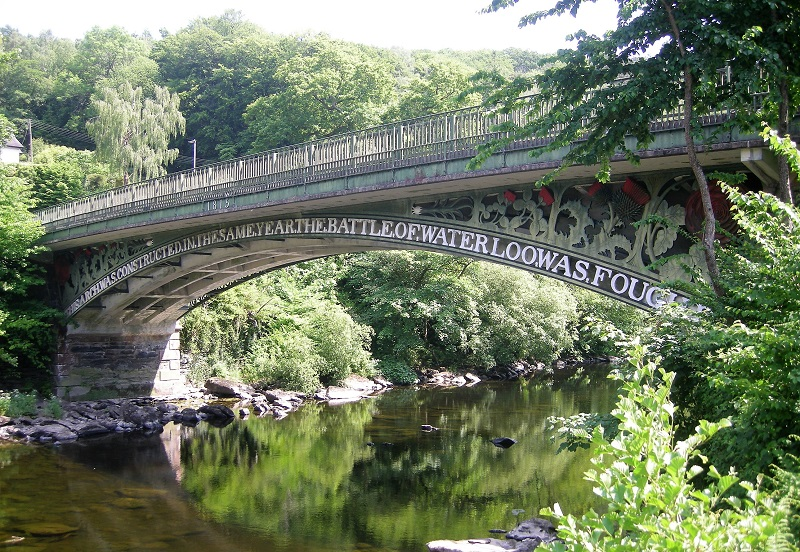
The first was the Waterloo Bridge over the Conway at Betws-y-Coed. The cast legend on the bridge reads: “This arch was constructed in the same year the Battle of Waterloo was fought,” though it was not actually completed until 1816.12
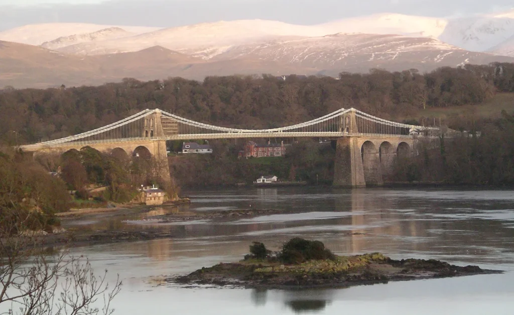
The second is the, more famous, suspension bridge across the Menai Strait, started in 1819, though not opened until 1826.13 At the time, it was the longest suspension bridge in the world, and stood thirty metres above the water to allow tall-masted ships so sail under it. Work has been done on it over the years, but Telford’s basic structure still carries the A5 over the Strait.
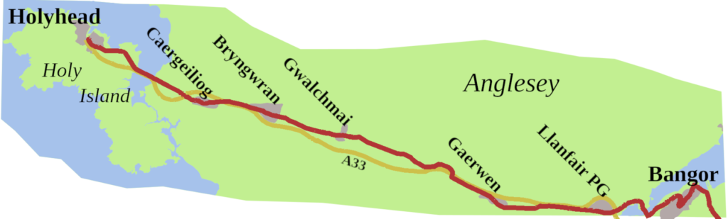
Once on Anglesey, faced with the dreadful state of the old turnpikes, Telford created an entirely new road. It went through Llanfairpwllgwyngyll (Llanfair PG), Gaerwen, Gwalchmai, Bryngwran, and Caergeiliog, with a 120-foot embankment across the Stanley Sands to reach Holy Island.
By the time he was finished, he had transformed the Holyhead road in Wales from being one of the worst roads in the land into one of the best. As a result, by 1828, the journey time for the New Royal Mail coach from London to Holyhead was 32 ¾ hours.14 He had also laid out the line of the future A5.
All Change
The railways eventually arrived, and from 1837, as lines were opened, coach routes closed.
The London to Holyhead mail coach through Shrewsbury ended in May 1838, though a coach continued to collect the Holyhead mail from Birmingham station until October 1847.
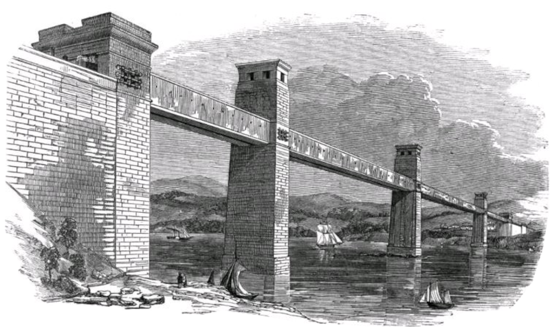
By 1850, Robert Stephenson’s Britannia Bridge was carrying the railway over the Menai Strait, which meant from then, the post went by train. For the Holyhead Road, the great days of the stage coach were over.
In a sense, the Welsh section of the road never recovered. Nonetheless, it was Telford’s route that the Ministry of Transport made the A5 through Wales.
Of course, changes have come. We now have the Chirk Bypass, finally opened in 1991. It runs north/south past the village, as far as the Halton Roundabout. Here you need to take the first exit, a sharp westerly turn, which takes you to the Whitehurst Roundabout, to connect with the old line of the A5.
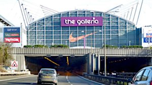
After Chirk, the 1923 version of the road picks up the modern A5 south of Pentre, and it is mostly Telford’s road until you come to the junction with the A55 North Wales Expressway. The A55 has become the dominant road, from the Llys Gwynt Interchange to Holyhead Port.
The A5, Telford’s A5, is still there, a two-way road, passing through the same towns and villages it did in his day. The Stanley Bank, affectionately known as The Cob, still carries the A5 onto Holy Island, and so to the port.
Back at the Menai Straits, there has been some chopping and changing. The A55 now runs along the upper deck of the new Britannia Bridge. Stephenson’s original burnt down in 1970, and its two-story replacement carried the A5 from 1980 to 2001. By then, the A55 had been made dual carriageway across Anglesey, and was routed over the Britannia Bridge, allowing the A5 to return to where it should be: Telford’s bridge.15
Today, few of us use the A5 through Wales to reach Holyhead. Your satnav, or route-finding app, will point you to the North Wales Expressway. However, the A5 is still the only single digit ‘A’ road in Wales, and it continues to mark the boundary between zones 4 and 5. You might drive it to reach Snowdonia, or simply to enjoy a leisurely trip through lovely countryside, offering, in places, some of the most majestic, and stirring views to be seen on this island.
The first three posts have all featured single digit roads, but the next post will be Part 1 of a 2 part look at the A57, which runns from Liverpool to Lincoln.
- Wright, Thomas, 1838. Queen Elizabeth and Her Times: A Series of Original Letters, Selected from the Inedited Private Correspondence of the Lord Treasurer Burghley, the Earl of Leicester, the Secretaries Walsingham and Smith, Sir Christopher Hatton, and Most of the Distinguished Persons of the Period, Volume 1, H Coburn ↩︎
- White, Kevan, 2018 Roman Britain: Rhyn Park, Roman Britain Website, http://roman-britain.co.uk/places/rhyn_park.htm ↩︎
- Cooke, Richard, 2016, Ty’n Y Llidiart, B5437, Corwen, Denbighshire, LL21 9RJ.October 2016 V 2.0, Aeon Archaeology ↩︎
- Wiles, John, 2007, Caer Llugwy, Bryn-y-Gefeiliau Roman Site, Royal Commission on the Ancient and Historical Monuments of Wales Website, http://www.coflein.gov.uk/en/site/95274/details/caer-llugwy-bryn-y-gefeiliau-roman-site ↩︎
- Wats, Edward, 1917, The Royal Mail to Ireland, Edward Arnold ↩︎
- Ogilby, John, 1699. The Traveller’s Guide, or a Most Exact description of the Roads of England, Abel Swall ↩︎
- Ayres, George, 2017. History of the Mail Routes to Ireland until 1850, Lulu.com ↩︎
- Ogilby, John, 1699. The Traveller’s Guide, or a Most Exact description of the Roads of England, Abel Swall ↩︎
- Cooke, Richard, 2011. Capel Horeb, Four Mile Bridge, Isle of Anglesey Archaeological Building Record, Gwynedd Archaeological Trust, ↩︎
- British Listed Buildings, The Cambria, British Listed Buildings Website ↩︎
- Rosevear, Alan, 2008. Turnpike Roads in England and Wales Website, http://www.turnpikes.org.uk/ ↩︎
- History Points, Waterloo Bridge, Betws-y-coed, HistoryPoints.org Website, http://historypoints.org/index.php?page=waterloo-bridge-betws-y-coed ↩︎
- Ayres, George, 2017, History of the Mail Routes to Ireland until 1850, Lulu.com. ↩︎
- Cary, John, 1828. Cary’s new itinerary; or, an accurate delineation of the great roads, both direct and cross, throughout England and Wales; with many of the principal roads in Scotland, Published by G & J Cary, 86 St James Street ↩︎
- Britannia Bridge, SABRE Website, https://www.sabre-roads.org.uk/wiki/index.php?title=Britannia_Bridge ↩︎